GED Social Studies Study Guide: Geography
On the GED Social Studies test, you’ll need to know more than how to read a map if you want to answer geography questions correctly. Our study guide below will cover the most important geography topics for success on test day.
Physical Geography
Physical geography refers to the physical environment and the living things it contains.
The Earth is divided into landforms and bodies of water.
Landforms include:
- Plains
- Mountains
- Canyons
- Basins
- Valleys
Bodies of water include:
- Oceans
- Seas
- Lakes
- Rivers
- Ponds
How landforms and bodies of water interact with living things makes up the ecosystem. Living things use the environment’s natural resources to thrive. Humans use natural resources differently than other animals, such as burning coal for electricity or melting iron to make steel.
The study of physical geography also involves climate, or trends in weather over thousands of years. Weather refers to a much shorter period of time, such as a week.
Note
Many eras of Earth’s climate history were much colder or hotter than it is at present day.
Continents and Oceans
The Earth’s Seven Continents
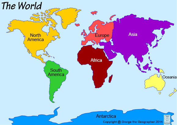
Source: The World of George The Geographer
Most geographers agree that the Earth can be split into seven continents. A continent is a large landmass usually separated from other landmasses by water. In the case of Europe and Asia, the Ural Mountains and cultural differences between the two regions draw a dividing line.
The Earth’s Five Oceans
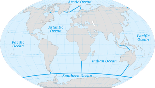
Source: Pinpin, CC BY-SA 3.0, via Wikimedia Commons
The Earth’s five oceans are a single body of water. The oceans have different names due to their relative locations to other things. The Arctic Ocean is in the Arctic Circle, while the Southern Ocean surrounds the southernmost continent, Antarctica.
Cultural Geography
Geologists also look at the Earth in terms of its diverse cultural regions. geographic boundaries and migration over tens of thousands of years created the cultural regions present today. As we already saw, the Ural Mountains are one of the main reasons that Asian and European cultures are so dissimilar. They prevented the diffusion, or the spread, of cultural traits between the two continents.
In other places, diffusion happens more easily. For example, the Chinese and Japanese written languages use similar characters. This is due to centuries of contact between the two groups.
As ideas are shared between peoples, so is culture, or the beliefs and values that make groups of people unique. Different cultural traits include child-rearing practices, religion, and social norms.
Reading Maps
Let’s explore everything you need to know about maps by examining the map below.
A Map of the Falkland Islands

Source:Eric Gaba (Sting – fr:Sting), CC BY-SA 3.0, via Wikimedia Commons
This map of the Falkland Islands provides a lot of useful information. Let’s start at the bottom, where you’ll immediately notice one box on the left and two boxes on the right.
The box on the left indicates elevation, with darker colors indicating higher elevation. Using shades of blue, the map also tells us how deep the ocean is.
The top box on the right provides us with the Falkland Islands’ exact location, just east of Argentina. In the box below it, a key explains what the circles, triangles, and lines on the map indicate. Here, we see that the red lines are roads, the circles are cities/settlements, and the triangles are mountain peaks.
Let’s not forget the scale in the bottom left corner. This important tool helps us figure out just how big the Falkland Islands are. It provides information in kilometers and miles. Kilometers are shorter than miles; 50 km is just over 30 miles.
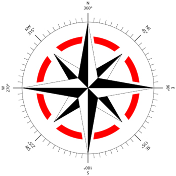
Lastly, can you spot something that’s missing from this map?
Hint
Besides the map’s orientation, is there any way to tell which way is north?
What’s missing is the compass rose:
Source: User:Vloeck, CC BY-SA 3.0, via Wikimedia Commons
The compass rose tells you which way is north, south, east, west, or in between. The compass rose is usually found in one of the corners of a map.
Once you’ve refreshed your memory on these critical geographic concepts, take our brief review quiz below to complete your GED Social Studies prep.